
Another weekend with high rain potential on deck
MACON, Georgia (41NBC/WMGT) – More cloud cover and increased rain chances are expected this weekend with a cold front arriving Sunday.
The Rest of the Evening
Mostly cloudy skies are likely into tonight, however a bit of clearing will be possible during the overnight hours. A couple of small showers will also be possible, however most of the region will stay dry. Winds will come from the southeast at around 5 mph. Temperatures will bottom out in the upper 40s and lower 50s, resulting in a much milder night than the rest of the week so far.
Saturday
Saturday will be mostly cloudy but rather warm with highs largely reaching into the lower 70s. Winds will be a bit breezy from the south as gusts push upwards of 17 mph. A few showers will be possible, especially later in the evening. The evening could also see a thunderstorm or two, but for the most part any thunderstorm activity should hold off until Sunday.


It will be a warm night with low temperatures only falling into the mid to upper 50s. Winds will remain rather breezy from the south with gusts reaching upwards of 20 mph (sustained 5-12 mph). Isolated showers will also be possible, especially leading up to Sunday morning.
Sunday
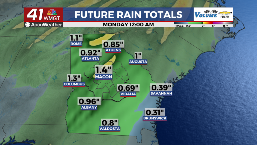
The cold front will arrive in Middle Georgia just ahead of lunchtime in Sunday. Thunderstorms will remain possible throughout the region into the late afternoon/evening hours. The SPC has highlighted the southeastern two 3rds of the region for a Level 1 “Marginal” risk for severe weather. Storm intensity will likely be limited by temperatures only climbing into the mid to upper 60s, however enough wind shear is present at the lower levels that a brief spin-up tornado cannot be ruled out if the conditions are right. Overnight clouds will clear out with northwesterly winds coming in at about 10-20 mph. Temperatures will bottom out in the low to mid 30s ahead of Monday morning. Rain totals for the weekend will likely fall between 1″-1.5″ around Middle Georgia.
Next Week
Expect a sunny start to give way to largely overcast skies by the end of the week. Temperatures will stay rather cool, however, with prevailing winds from the northeast taking over on Tuesday.

Follow Meteorologist Aaron Lowery on Facebook (Aaron Lowery 41NBC) and Twitter (@ALowWX) for weather updates throughout the day. Also, you can watch his forecasts Monday through Friday on 41NBC News at 4, 5, 5:30, 6, and 11 PM.