Rain returns to Middle Georgia Friday
MACON, Georgia (41NBC/WMGT) – Rain chances and temperatures will rise ahead of a slow moving frontal system this weekend.
The Rest of the Evening


The mostly cloudy conditions that took over Middle Georgia today won’t be going anywhere anytime soon. They will only thicken more as the evening and night pass on. Winds will shift more towards the southeast at about 5-10 mph. A shower or two will be possible after midnight, especially for the northern half of the region. Temperatures will also be much warmer than the past couple of nights as they only bottom in the low to mid 40s.
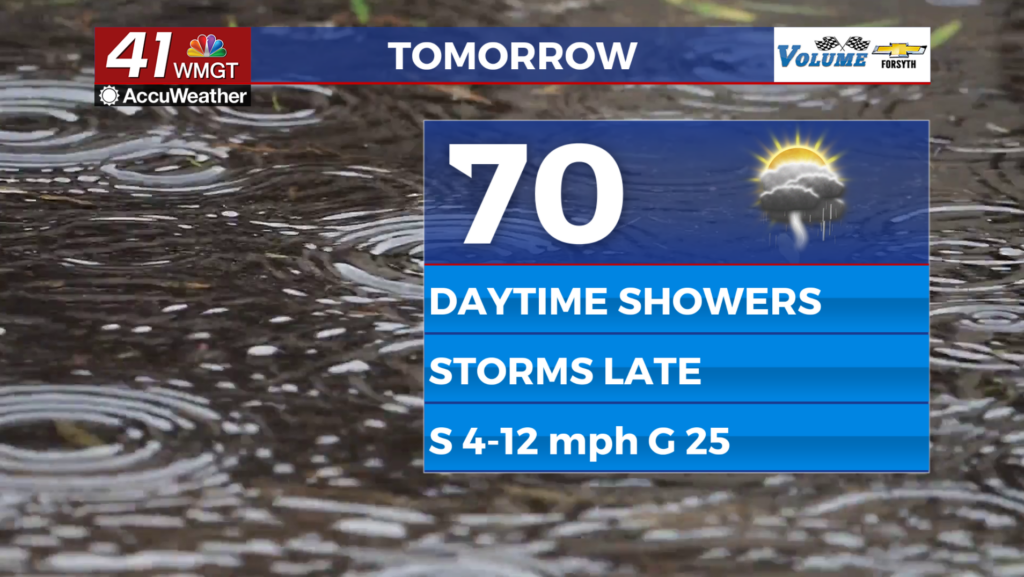
Tomorrow


Mostly cloudy skies are likely most of Friday afternoon with temperatures likely to reach the upper 60s and lower 70s. Some isolated showers will be possible during the day before some thunderstorms move in later in the evening. Winds will be a bit breezy from the south at about 5-15 mph. Gusts, however, could push as high as 20-25 mph.


Tomorrow evening and into the early overnight hours is when the first round of thunderstorms is expected. At this time no severe weather is expected, but heavy rain, lightning, and strong winds will all be possible with storms. Overnight lows will drop into the upper 50s and lower 60s ahead of Saturday morning. More heavy rain could move in ahead of or around sunrise Saturday as well.
The Weekend and Beyond


Saturday is the saturated day with the bulk of the rain expected to arrive early. A second round of storms is likely headed into the evening, however. Temperatures will reach the upper 60s and lower 70s with winds from the south-southwest likely at about 5-15 mph. Gusts could reach upwards of 30 mph, however. In terms of the storms for Saturday, the SPC has gone ahead and issued a Level 1 “Marginal” risk that includes most of Middle Georgia. The primary risk will be flash flooding and strong winds, however a brief spin-up tornado cannot be ruled out.


Sunday likely will not see severe weather threats, however scattered storms are likely with highs reaching into the lower 70s. Conditions should get nicer come Monday, however cloud cover will likely stick around to some degree through Wednesday.

Follow Meteorologist Aaron Lowery on Facebook (Aaron Lowery 41NBC) and Twitter (@ALowWX) for weather updates throughout the day. Also, you can watch his forecasts Monday through Friday on 41NBC News at 4, 5, 5:30, 6, and 11 PM.